
A devastating weather system that unleashed nearly 100 tornadoes across the American Midwest and South has now shifted focus to an equally dangerous threat: catastrophic flooding. The same slow-moving front responsible for Wednesday’s tornado outbreak has stalled over the confluence of the Ohio and Mississippi rivers, creating conditions for what meteorologists are calling a “potentially historic” flooding event.
With at least seven fatalities already reported from the tornado activity, communities from Arkansas to Michigan now face the prospect of record-breaking rainfall and river levels that could exceed once-in-a-thousand-year thresholds.
The crisis comes at a particularly challenging time for federal disaster response agencies, which are operating with significantly reduced staff following recent budget cuts and reorganization efforts.
Tornado Outbreak Breaks Records
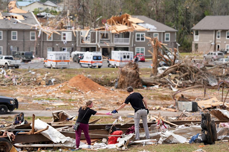
Wednesday’s tornado activity represented one of the most significant single-day outbreaks in recent memory, with the National Weather Service issuing 284 tornado warnings – a number exceeded only during the historic April 2011 outbreak.
The tornadoes formed an almost continuous line stretching nearly 1,000 miles from Arkansas to Michigan, with some of the strongest storms producing radar-estimated winds approaching 200 mph near Jonesboro, Arkansas.
The outbreak resulted in at least seven confirmed fatalities, including three deaths in Selmer, Tennessee, and additional casualties in Missouri. Multiple EF3 tornadoes caused significant destruction, with one particularly devastating twister moving through Lake City, Arkansas, prompting tornado emergency declarations.
The severe weather affected 18 counties in Indiana alone, where 12 tornadoes touched down, causing extensive damage to homes and farms just before the critical spring planting season.
Unprecedented Flooding Threat Emerges
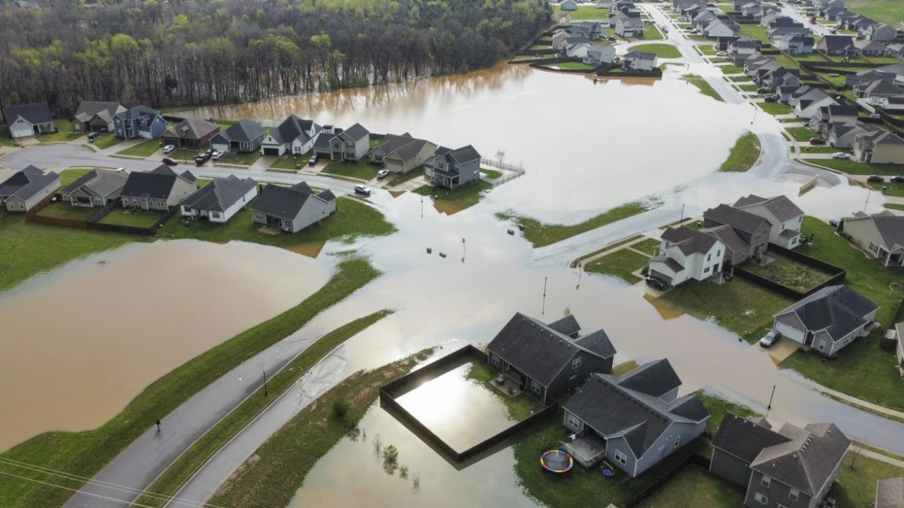
As the tornado threat subsides, attention has turned to an even more dangerous flooding scenario. The same weather system responsible for the tornadoes has stalled over the region, creating conditions for what the National Weather Service describes as a “life-threatening, catastrophic, and potentially historic flash flood event.”
Memphis, Tennessee, is expected to receive more than 12 inches of rainfall over a three-day period – an amount that typically occurs less than once in a thousand years under stable climate conditions. The city had already recorded nearly 7 inches of rain in the three days leading up to the forecast, representing more precipitation than normally falls during the entire month of April.
Nashville experienced its second-wettest April day on record since 1871, with nearly a month’s worth of rain falling in a single day. The excessive rainfall has prompted flash flood warnings across much of central and western Kentucky, with nearly 40 rivers from Arkansas to southern Indiana forecast to reach major flood stage.
River Systems Reach Critical Levels
Major river systems across the region are approaching or have already reached historic flood levels. The Ohio River in Louisville, Kentucky, crested at nearly 37 feet, 20 feet above flood stage and the eighth-highest level in recorded history. In Owensboro, Kentucky, the river reached 47.5 feet, making it the sixth-highest level on record.
The Mississippi River in Osceola, Arkansas, recorded a crest of 37.6 feet, nearly 10 feet above flood stage and classified as major flooding. Some areas from Kentucky into Tennessee and Arkansas received over a foot of rainfall during the event.
Federal Response Capabilities Strained
The disaster response comes at a challenging time for federal emergency management agencies. The Federal Emergency Management Agency (FEMA) has recently implemented significant staffing changes, with approximately 2,000 employees either accepting incentives to leave or being terminated since the start of the Trump administration.
A draft memo reveals that FEMA plans to require nearly all full-time employees to be deployed to emergency zones, with staff expected to spend 45 to 90 days per year in disaster areas. This represents a major shift from previous operations, where only about 22% of the agency’s permanent full-time employees were typically deployed to disaster zones.
The National Weather Service has also faced staffing challenges, with critical vacancies affecting five of the 12 River Forecast Centers operated by NOAA. These staffing shortages come at a time when extreme weather events are becoming more frequent and intense, testing the capacity of increasingly stretched federal agencies.