

The central United States faced a devastating weather catastrophe in early April 2025, as a slow-moving storm system unleashed both deadly tornadoes and catastrophic flooding across multiple states. From April 2-7, this weather event proved to be one of the most destructive in recent memory, claiming at least 18 lives and causing widespread destruction from Texas to Ohio.
The combination of violent tornadoes, torrential rainfall exceeding 15 inches in some areas, and rapidly rising rivers created what meteorologists described as a “once in a generation” disaster. Communities that had never experienced flooding found themselves underwater, while tornado-ravaged neighborhoods faced additional devastation from flash floods.
The storm’s slow progression eastward meant that the misery was prolonged, with some areas receiving three times their typical April rainfall in just a few days.
Tornado Devastation Across Multiple States
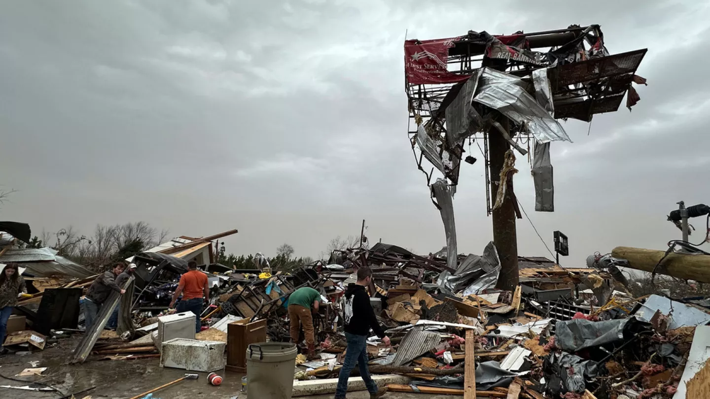
The tornado outbreak began on April 2 when the Storm Prediction Center issued a rare high-risk warning for severe weather. The destruction was swift and merciless across several states. In Tennessee, the hardest-hit state, at least 10 people lost their lives to the storms. An EF3 tornado struck Selmer, Tennessee, in the early morning hours of April 3, killing three people within the city and two others in surrounding McNairy County.
Missouri also suffered significant tornado damage, with an EF2 tornado destroying a manufactured home in Pilot Grove and tossing cars, though fortunately, no one was injured despite tornado sirens failing to sound due to a malfunction. Arkansas experienced a large, multiple-vortex EF3 tornado that moved through Lake City, prompting emergency officials to issue a tornado emergency. The violent weather system spawned tornadoes from Arkansas to Illinois, with some reaching EF3 classification and wind speeds between 136 and 165 miles per hour.
Historic Flooding Overwhelms Communities
While tornadoes grabbed initial headlines, the flooding proved equally devastating and longer-lasting. Kentucky bore the brunt of the flood damage, with peak rainfall accumulations exceeding 15 inches near Benton and Hickory. The state’s capital, Frankfort, experienced record-breaking flooding as the Kentucky River crested at 48.27 feet on April 7 – 17 feet above normal flood stage and just short of the 1978 record.
Infrastructure and Emergency Response
Governor Andy Beshear reported that approximately 540 roadways, mostly in western Kentucky, were closed due to flooding, while 1,100 people lost water services. The flooding was so severe that Frankfort’s mayor issued a citywide curfew, and officials shut off power and gas to businesses in the flood-prone downtown area. Emergency responders conducted numerous water rescues, with Nashville’s fire department alone performing over a dozen rescues.
Regional Impact and Economic Consequences
The flooding extended far beyond Kentucky’s borders. Louisville Mayor Craig Greenberg warned that the Ohio River’s 5-foot rise in 24 hours would make this “one of the top 10 flooding events in Louisville history.” The extreme weather affected major cargo hubs in Louisville and Memphis, threatening to cause shipping and supply chain delays across the region.
In Arkansas, a 5-year-old child died in Little Rock in a weather-related incident, while BNSF Railway confirmed that flood waters washed out a railroad bridge in Mammoth Spring, causing several train cars to derail. Emergency officials in north-central Kentucky ordered mandatory evacuations for Falmouth, a town of 2,000 people threatened by the rising Licking River.
Meteorological Factors and Warnings
The National Weather Service attributed the violent weather to a perfect storm of conditions: warm temperatures, an unstable atmosphere, strong wind shear, and abundant moisture streaming from the Gulf of Mexico. Forecasters issued their highest-level warnings, describing the event as having a return interval of 25 to 100 years.
The Weather Prediction Center labeled the situation an “extreme flooding scenario” due to its prolonged nature, with some areas potentially receiving rainfall totals that occur “once in a generation to once in a lifetime.” The storm’s slow eastward progression meant that affected areas endured days of continuous rainfall, leading to soil saturation and exacerbated flooding conditions.
This catastrophic weather event highlighted the vulnerability of central U.S. communities to extreme weather and underscored the challenges facing emergency responders during multi-hazard disasters combining both tornadoes and flooding.