

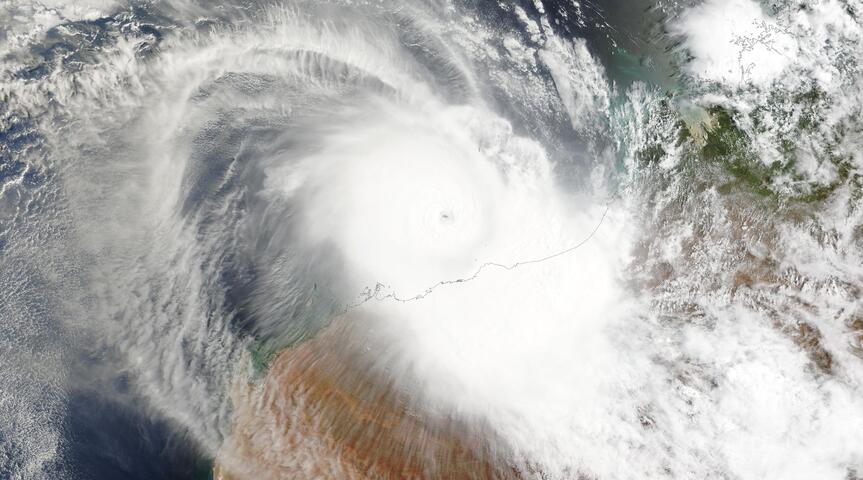
Australia faces a tale of two weather extremes this weekend, with the Bureau of Meteorology issuing warnings for both a developing tropical cyclone off Western Australia’s coast and unseasonably warm temperatures across the southeast. The weather bureau has identified tropical low 29U in the Timor Sea northwest of Darwin as a significant threat, predicting it will intensify into Cyclone Errol as it moves southwest toward the Kimberley region.
This development comes as a massive high-pressure system simultaneously drives temperatures up to 12 degrees above average in Victoria and New South Wales, creating a stark contrast in weather conditions across the continent.
Cyclone Formation and Intensification Forecast
The tropical low currently designated as 29U began forming on April 9 in the northern Arafura Sea and has been tracking westward before turning southwest. Meteorologists expect this system to reach cyclone intensity by Saturday, with Weatherzone’s Ben Domensino predicting significant strengthening over the following days. The warm waters off Western Australia’s coast, with sea surface temperatures hovering around 30-31°C, provide ideal conditions for rapid intensification.
Forecast models suggest the system could evolve into a Category 3 severe tropical cyclone by Tuesday, though its compact size may allow for even more dramatic strengthening. The cyclone’s small diameter works in its favor for rapid intensification, as smaller systems can gain strength more quickly than their larger counterparts. Environmental factors, including low wind shear and excellent upper-level outflow patterns, further support the system’s development potential.
Coastal Impact Preparations and Safety Measures
The Western Australia Department of Fire and Emergency Services has issued advisory warnings for residents along a 450-kilometer coastal stretch from Cockatoo Island to King George River. While the cyclone is not currently expected to make direct landfall, it could approach close enough to the Kimberley coast to generate dangerous conditions. Officials emphasize that although no immediate danger exists, residents must begin preparation activities immediately.
Emergency preparation recommendations include securing boats, caravans, outdoor structures, and furniture that could become projectiles in high winds. Authorities strongly advise stocking emergency supplies sufficient for five to seven days, including canned food, water, first aid supplies, medications, cash, and battery-powered radios for receiving weather updates. The proximity of the system to populated areas means that even without direct landfall, damaging wind gusts, heavy rainfall, and abnormally high tides could significantly impact coastal communities.
Record-Breaking Cyclone Season Context
Should tropical low 29U develop as predicted, Cyclone Errol would mark the eighth named storm of the 2024-25 Australian cyclone season, representing the highest seasonal total in 19 years. This exceptional activity level reflects broader patterns of increased tropical cyclone frequency in the region.
The season has already witnessed significant impacts from previous systems, including ex-Tropical Cyclone Dianne, which devastated parts of the Northern Territory and Queensland with extraordinary rainfall totals in March.
The rapid succession of tropical systems highlights the ongoing challenges facing northern Australia during what has become an unusually active cyclone season. Ex-Tropical Cyclone Alfred also caused substantial damage across southeastern Queensland and northeastern New South Wales earlier in the season, demonstrating the widespread impact potential of these weather systems.
Southeast Australia’s Unseasonable Heat Wave
While Western Australia prepares for tropical weather, the southeastern states are experiencing dramatically different conditions. A large, slow-moving high-pressure system extending from southeastern Australia into the Tasman Sea is driving temperatures well above seasonal averages. Melbourne is forecast to reach 30°C on both Saturday and Sunday, marking the city’s warmest April temperatures in four years.
Sydney will also experience elevated temperatures, with maximums of 26°C expected throughout the weekend. These readings represent significant departures from typical April weather patterns, with some areas experiencing temperatures up to 12 degrees above average. The high-pressure system’s size and persistence suggest these warm conditions may continue beyond the immediate weekend period.
Forecast Uncertainty and Monitoring Requirements
Meteorologists emphasize that tropical cyclone predictions remain challenging during early development stages, with forecast accuracy improving as systems mature and additional observational data becomes available. The current trajectory suggests Cyclone Errol will remain offshore, but residents must stay informed as conditions can change rapidly. The Bureau of Meteorology continues monitoring the system’s development closely, with updated forecasts and warnings issued as new information becomes available.
The contrasting weather patterns across Australia this weekend underscore the continent’s diverse climate zones and the complex meteorological systems that influence regional conditions simultaneously.