
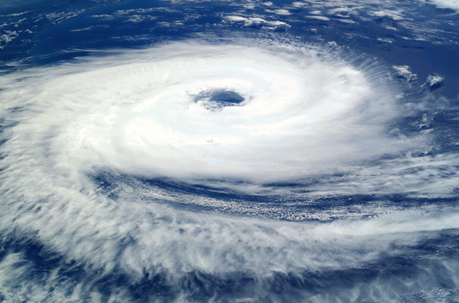
An extraordinary weather event is unfolding off Queensland’s coast as Tropical Cyclone Alfred positions itself to potentially strike one of Australia’s most densely populated regions. More than 4 million residents spanning from Bundaberg to the Gold Coast find themselves in what authorities describe as the “firing line” of a weather system that could reshape the southeastern coastline.
Premier David Crisafulli has activated precautionary measures across the state, emphasizing the unprecedented nature of a tropical cyclone threatening such a heavily populated area. The Bureau of Meteorology’s latest modeling suggests Alfred will pivot westward toward the coast this week, with Thursday emerging as the most likely landfall scenario.
This represents a rare meteorological occurrence, as tropical cyclones seldom venture this far south to impact major population centers directly..
Unprecedented Threat to Major Population Centers
The cyclone’s projected path encompasses a vast 450-kilometer stretch of coastline extending from Bundaberg to the New South Wales border, placing Queensland’s most densely populated areas directly in harm’s way. Premier David Crisafulli emphasized the gravity of the situation during Sunday’s briefings, describing Alfred as “a large system that presents a big challenge for a large part of the Queensland coastline”.
The Bureau of Meteorology has indicated that Thursday represents the most probable timeframe for landfall, with the system expected to begin its westward turn toward the coast on Tuesday. This timing has prompted authorities to accelerate preparation efforts across the region, recognizing that the sheer number of potentially affected residents requires extensive coordination.
Dangerous Conditions Already Emerging
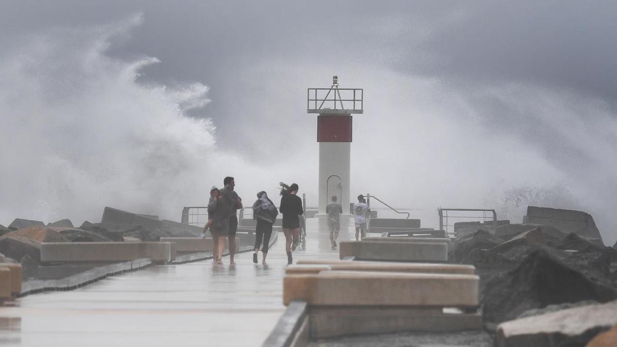
Even while remaining offshore, Alfred has already begun demonstrating its destructive potential. Coastal monitoring stations recorded towering 14-meter waves along Queensland beaches on Sunday, providing a stark preview of the system’s power. The prolonged presence of the cyclone off the coast has generated massive easterly swells that are battering exposed beaches from southern Queensland into northern New South Wales.
Senior meteorologist Matthew Callopy warned that Alfred could maintain Category 2 intensity upon landfall, bringing with it a devastating combination of destructive winds, coastal inundation, and torrential rainfall. Rainfall projections suggest some areas could receive between 300 and 600 millimeters over multiple days, with the heaviest precipitation expected along the southern edge of the storm system.
Historical Context and Rarity
The potential impact of Alfred on southeastern Queensland represents a meteorological anomaly that underscores the event’s significance. Historical records show that tropical cyclones rarely penetrate this far south along Australia’s eastern seaboard. The last comparable event occurred in 1974 when Cyclone Wanda crossed the coast near Brisbane, making Alfred’s approach particularly noteworthy for both meteorologists and emergency planners.
Previous cyclones that have affected the region include Tropical Cyclone Nancy in 1990, which tracked erratically toward Brisbane before ultimately turning away without making landfall, and the infamous Cyclone Wanda, which contributed to Brisbane’s catastrophic 1974 floods after crossing near K’gari and Hervey Bay. More recently, Cyclone Debbie in 2017 demonstrated how tropical systems can impact southeastern areas after initially making landfall further north and tracking overland.
Emergency Preparations Intensify
Queensland’s emergency management apparatus has shifted into high gear as the cyclone approaches. Premier Crisafulli announced that the state has entered a “precautionary phase,” with plans to pre-deploy emergency response teams throughout potentially affected areas. Telecommunications providers have been contacted to ensure adequate bandwidth availability for emergency communications, recognizing that widespread power outages could complicate rescue and recovery efforts.
The Bureau of Meteorology has issued warnings for severe coastal hazards extending beyond Queensland into northeastern New South Wales. These warnings encompass not only the immediate landfall zone but also areas that could experience dangerous storm surge and abnormally high tides. K’gari has already been placed under gale-force wind warnings as the system continues its approach.
Community Response and Preparation
Authorities are emphasizing the importance of community preparedness given the unprecedented nature of the threat. The combination of Alfred’s size, intensity, and the density of population in its projected path creates unique challenges for emergency management. Coastal erosion, flash flooding, and extended power outages represent the primary concerns as communities brace for impact.
The cyclone’s slow movement pattern has both advantages and disadvantages for preparation efforts. While the deliberate pace provides additional time for evacuation and preparation activities, it also means that affected areas will endure prolonged exposure to dangerous conditions, potentially extending the duration of impacts well beyond the initial landfall.
As Alfred continues its approach, Queensland residents are being urged to finalize their emergency preparations and remain vigilant for rapidly changing conditions that could alter the storm’s projected path and intensity.