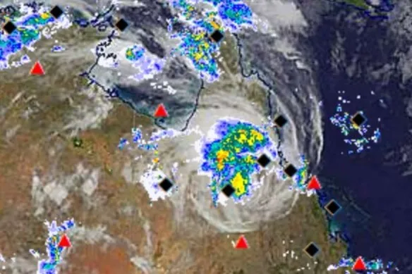
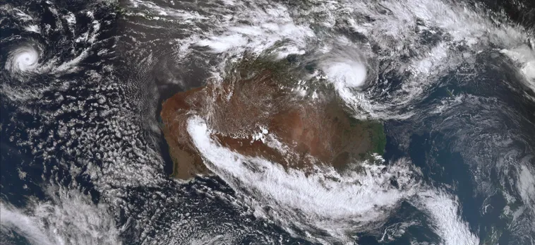
As Tropical Cyclone Kirrily made its way across the coast of Queensland, it brought with it heavy rain and very strong wind gusts, sparking concerns that areas inland could be hit with a deluge. The cyclone had been upgraded to a category-three storm on Thursday afternoon and crossed the coast at Townsville at 10pm, only to be downgraded to a category-one storm as it moved inland.
Wind gusts of up to 82km/h were reported in Townsville, with the Bureau of Meteorology warning that conditions would ease further in the coming hours. However, the bureau also cautioned that the system could still bring strong winds and heavy rain as it moves inland, pushing moisture through central and western parts of Queensland.
Meteorologist Miriam Bradbury explained that as the system makes its way inland, it will carry a lot of moisture with it, gradually pushing it through central and then more western parts of the state. The Queensland BoM issued a severe weather warning for the area between Cairns and Port Douglas, warning of winds in excess of 100km/h in boostd terrain and valleys.
The state government has pre-emptively declared a disaster and requested assistance from the federal government and other states. Premier Steven Miles assured the public that the government was prepared and ready for the worst, with the SES already receiving 146 calls for assistance, most related to sandbagging.
 Tropical Cyclone Kirrily
Townsville Mayor Jenny Hill urged residents to shelter in place from 2pm local time, when wind gusts above 80km/h were forecast, and expected them to stay indoors until Friday morning. Residents were advised to finish any essential shopping and to avoid sandbagging locations.
The cyclone was located 420km east-north-east of Townsville on Thursday morning, before moving inland and reducing in strength. At 4pm, it was estimated to be 120km east-northeast of Townsville and 325km north-northwest of Mackay. The Bureau of Meteorology warned all communities within the warning zone were at risk of heavy rainfall and possible flash flooding over the coming days.

The city’s residents were preparing for the worst, with 50 residents in low-lying areas choosing to evacuate their homes and stay with family and friends. Over 40,000 sandbags had already been used, and more than 120 schools across northern Queensland were closed as a precaution ahead of the looming weather event. Almost 1,000 homes were without power in Townsville, while 460 were without power in the Whitsundays. Water police and the Queensland police service were on standby to assist with any response.
The state’s disaster coordinator, deputy commissioner Shane Chelepy, urged residents to stay off the roads and take necessary precautions to keep themselves safe. He also warned that intense rainfall and wind were expected over the next 12 hours, and advised those who did not feel safe in their homes to consider moving to an evacuation center or cyclone shelter.