Hurricane Beryl is targeting the western Caribbean Sea, including Jamaica, the Cayman Islands, and the Yucatan Peninsula, before potentially impacting Texas and possibly Louisiana in the Gulf of Mexico.
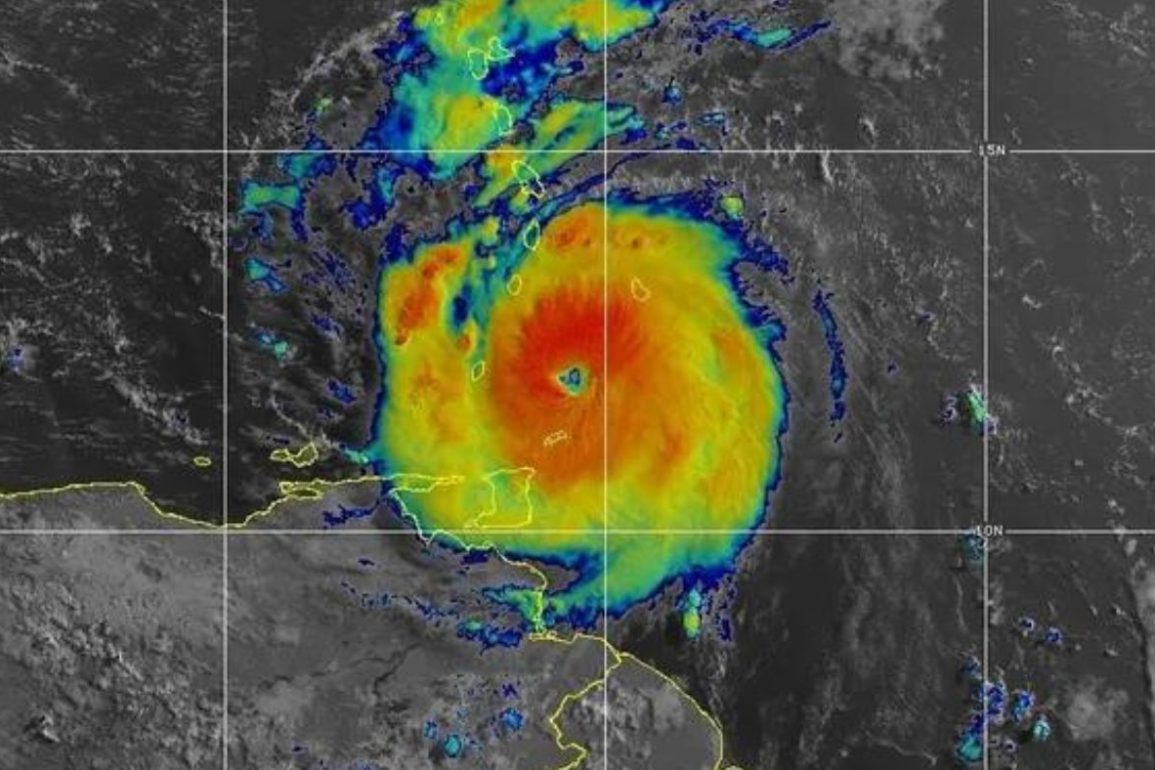
Currently, Beryl continues to move quickly west-northwest in the eastern Caribbean Sea at Category 4 intensity, positioned well south of both Puerto Rico and Hispaniola. However, some outer bands of heavy rain have already reached those areas.
Beryl became the earliest hurricane to reach Category 5 strength on record in the Atlantic, achieving this over two weeks earlier than the previous record set by Hurricane Emily on July 16, 2005. For a full recap of all the early-season records Beryl has broken, check out our comprehensive report.
A hurricane warning has been issued for Jamaica and the Cayman Islands, while a hurricane watch is now in effect for southern Hispaniola.
Additional alerts could be issued later on Tuesday or Wednesday. Areas under hurricane warnings should complete their preparations urgently, while those under hurricane watches should ensure their hurricane plans are ready.
Beryl is expected to follow a west-northwest track in the Caribbean Sea for the rest of this week. Although it will eventually weaken due to increasingly hostile wind shear, it will still pose a significant threat. Here’s the general timeline:
– Through Early Wednesday: Beryl’s outer impacts, including bands of flooding rain, some storm surge flooding, and occasional strong winds, could brush southern Hispaniola.
– Wednesday: Beryl is expected to hit Jamaica with destructive winds, life-threatening storm surge flooding near the coast, and torrential rainfall, leading to flash flooding and landslides before moving away late Wednesday night. This could be the strongest hurricane to strike Jamaica in almost 17 years, since Hurricane Dean in 2007.
– Thursday: Beryl is forecast to make its closest approach to the Cayman Islands, particularly Grand Cayman, with storm surge flooding, high winds, and heavy rain.
– Friday: Beryl is expected to make landfall as a hurricane in Mexico’s Yucatan Peninsula, anywhere from the Belize border and Costa Maya to Cancún. Storm surge flooding, potentially damaging winds, and flooding rain are all possible.
Beryl is likely to emerge in the southwest Gulf of Mexico this weekend, steered by a heat dome of high pressure over the Southeast U.S. However, there is considerable uncertainty about Beryl’s future after that.
The Southeast U.S. upper-level heat dome is expected to weaken and retreat off the Southeast coast, creating a gap that could allow Beryl to turn northwest or north in the western Gulf of Mexico. This opens the possibility of a track anywhere from eastern Mexico’s Gulf Coast to Texas or even Louisiana early next week.
 Hurricane Beryl (Credits: Ricardo Mazalan)
By the time Beryl reaches the southwest Gulf, it should have weakened due to wind shear and land interaction.
Nevertheless, it could still bring significant impacts to the Gulf Coast as either a tropical storm or hurricane. Residents along the Gulf Coast from eastern Mexico to Texas and Louisiana should monitor the forecasts in the coming days.
Coastal threats could begin this weekend: Onshore winds ahead of Beryl could lead to increasing surf, rip currents, and coastal flooding along parts of the Gulf Coast from eastern Mexico to Texas and western Louisiana starting as soon as Saturday and continuing until Beryl’s final landfall.
The rip current threat could even extend farther east along the northern Gulf Coast.
If you have holiday weekend beach plans along these stretches of the coastline, keep this in mind. Just a couple of weeks ago, Tropical Storm Alberto triggered significant coastal flooding along the Texas coast.

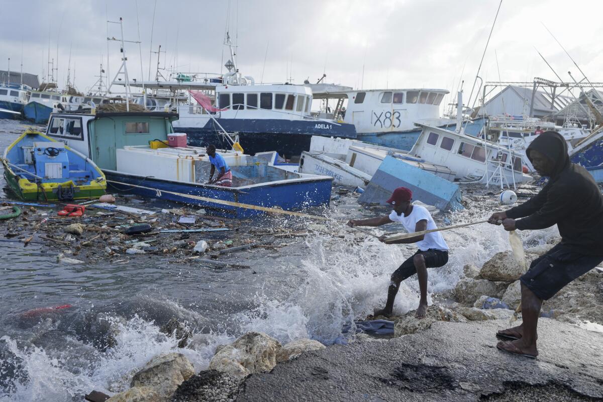
Recap of Beryl’s historic Windward Islands landfall: Beryl made landfall just after 11 a.m. EDT Monday over the Grenadan island of Carriacou with maximum sustained winds of 150 mph.
Among only two other Category 4 hurricanes in history near Grenada and St. Vincent and the Grenadines, Beryl was the strongest by wind speed.
Storm reports: Storm chasers Brandon Clement and Jonathan Petramala reported the roof was ripped off a building they were in on Carriacou Island late Monday morning as the eyewall moved in.
The National Hurricane Center’s 11 a.m. EDT Monday advisory cited “multiple reports of downed trees, flooded streets, power outages, and storm surge flooding in the Grenadines, Grenada, Barbados, and Tobago.”
After briefly weakening to a Category 3 overnight following an eyewall replacement cycle, the hurricane returned to Category 4 strength Monday morning. Its wind field grew larger since Sunday, with hurricane-force winds now extending up to 40 miles from Beryl’s center.
While its eyewall passed south of Barbados, a 69 mph gust was recorded early Monday at Grantley Adams International Airport, the island’s major airport.
Grenada clocked a wind gust up to 121 mph as the center of Beryl tracked just north of the island. A gust of 64 mph was reported on St. Lucia, as well.
Beryl has strengthened since that strike on Carriacou Island.