Unprecedented high atmospheric pressure is currently being observed across south-east Australia, including a preliminary new national record measured in Tasmania this morning.
The weather station at Sheffield reported a pressure of 1,044.6 hectopascals (hPa) at 10:30 am, which, if confirmed, beats the previous Australian record of 1,044.3 hPa set in Launceston on June 7, 1967.
The potential record is slightly contentious due to changing observation frequencies and techniques between now and 1967.
However, the high pressure looks likely to peak again near 1,044 hPa early Saturday, providing another opportunity for a record before the system weakens from Sunday.
The abnormal pressure is significantly impacting the nation’s weather, including extreme low overnight temperatures over south-east states and a lengthy stretch of showery days along the eastern seaboard.
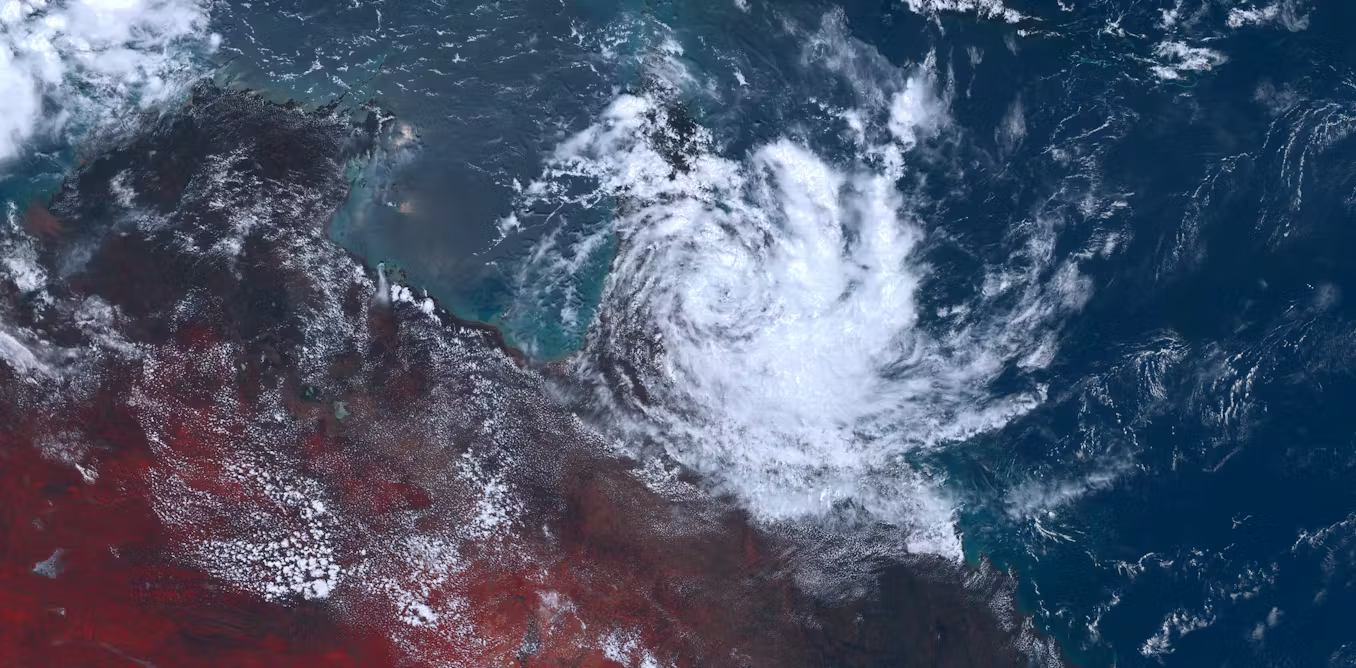
A high-pressure system near Tasmania has been analyzed to have a central pressure well above 1040 hPa.
The current atmospheric record is due to an intense high-pressure system anchored near Tasmania, which is not only very strong but also exceptionally broad and slow-moving.
The high’s incredible size will allow the system to control the weather this week from Fiji to a few hundred kilometers off the WA west coast — a distance of about 7,000 km.
So how is the record pressure impacting the weather? While highs generally bring mostly settled conditions, the precise weather this week around Australia is largely dependent on a location’s position relative to the system’s center.
The most extreme conditions have occurred near the middle of the high over southern states where clear skies, light winds, and very dry surface air have caused icy cold nights.
Although frosty nights are common under a high in winter, the additional presence of polar air in the wake of a weekend front has allowed minimums to drop as much as 12 degrees below average this week, even breaking a handful of records in Tasmania and South Australia.
While the southern states are shivering, the record high is leading to a prolonged spell of wet days along the east coast.
Since winds blow anti-clockwise around highs, Queensland and NSW are stuck in prevailing south-easterly winds, an onshore direction which is blowing in showers off the Tasman and Coral seas.
 Australian High (Photo: NASA, MODIS)
Conversely, on the west coast, northerly winds are blowing, bringing above-average temperatures to Perth this week.
High-pressure systems form when air descends towards the surface, explaining why they normally bring clear weather since rising air is required for thick cloud and rain.
The current system’s central pressure has soared well above your typical high due to lingering polar air over southern Australia and a decelerating jet stream which is enhancing the amount of air pushing towards the ground from high altitude.
“Two of the main factors are the subsidence associated with the jet stream across central/eastern Australia and the broad pool of cold and dense air across the country and waters to the south,” a Bureau of Meteorology (BOM) spokesperson said.
While barometer readings above 1,040 hPa are rare by Australian standards, the pressure is well below the almost daily readings observed across eastern Russia in winter where intense cold and dense air lead to a semi-permanent strong anti-cyclone called the “Siberian high.”
According to the World Meteorological Organization, the highest global air pressure from the Siberian High sits at 1,084 hPa (or 1,089 hPa for an elevated location reduced to sea level).
The most noticeable impact of high air pressure, besides the weather, is a lowering of sea levels as the increased pressure pushes down on the water.
A difference of one hectopascal from the average can cause a change in sea level of about 1 centimeter.
Considering pressure is currently about 30 hPa above normal, the BOM expects sea levels over south-east Australia will drop accordingly.

“We expect sea levels near the center of the high-pressure system to be about 30 cm lower than usual under average weather conditions.”
The depression in sea levels under high atmospheric pressure is the reverse of the coastal flooding which results from very low pressure associated with tropical cyclones.
So can humans detect a change in atmospheric pressure of 30 hPa? A frequent discussion point is how pressure impacts conditions like arthritis.
A 2019 study published in Nature concluded a moderate link between pressure and chronic pain, with the odds of pain lower with an increase in atmospheric pressure.
This research offers hope that the current spell of record high pressure could lead to reduced symptoms from arthritis, although the findings are inconclusive to the actual cause since the weather impacts human behavior.
It’s hypothesized by some doctors and researchers that changed behavior due to weather, for example, staying inside during wet days, is affecting pain rather than the direct impact of the weather itself.
It took more than half a century to break Australia’s air pressure record, but if weather trends continue, the next challenge could occur in a much shorter time span.
Data from the BOM shows both the density and intensity of highs have increased since 1950 around Australia, meaning not only are high-pressure systems more frequent, they are also slowly gaining in strength.
The shift towards stronger highs around the mid-latitudes is a well-researched trend related to shifts in the position of weather systems around the world, including a contraction of low-pressure systems away from southern Australia in winter as outlined in the BOM’s most recent State of the Climate Report.
“There has been an increase in the number of high-pressure systems over southern Australia, which bring dry, clear weather and little rainfall,” the report said.