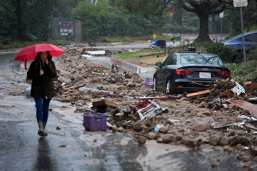
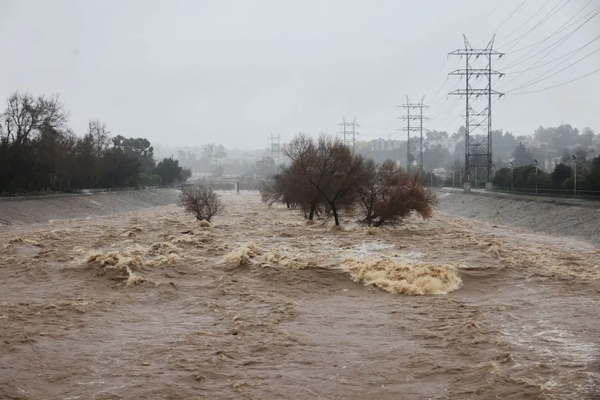
Atmospheric rivers, the powerful storms that have besieged California during its unusually wet winter, have already dumped a staggering 30 trillion gallons of water across the state, burying mountain towns in snow and causing widespread flooding. And the worst may not be over yet, with more of these severe storms expected to continue into the spring.
So, what exactly are these atmospheric rivers? In short, they are long streams of overhead moisture that have the power to deliver both destructive and drought-reducing downpours across the state with alarming intensity. The National Oceanic and Atmospheric Administration (NOAA) simply refers to them as “the rivers in the sky.”
These storms are supercharged by warm water vapor evaporating off the Pacific Ocean, loading them with enough water to rival the average flow of the mighty Mississippi River, or even 15 times its volume. As they move with weather systems, they appear as a trail of wispy clouds that can stretch for hundreds of miles, ready to unleash deluges wherever they make landfall.
At the same time, atmospheric rivers play a crucial role in California’s water cycle, providing roughly half of the state’s annual precipitation. However, their power and quick succession this year have increased the dangers. On top of huge amounts of water, which can overload rivers and reservoirs, dangers can include strong gusty winds, which are responsible for an overwhelming majority of the flood damage across the western US in recent decades.
Dr. Marty Ralph, director of the Center for Western Weather and Water Extremes and researcher at Scripps Institution of Oceanography, notes that the frequency and intensity of these storms will only increase as the climate crisis worsens. “Whether there are too many or too few determines whether parts of California are above or below normal in precipitation,” he said. “When you get a couple of them back to back, especially if the watersheds are already very wet, we start to see the pile-on effects.”
 The Rivers in the Sky Bring Record Flooding to California’s Doorstep
California’s climate has long fluctuated dramatically from wet to dry, but models show these shifts will occur with increasing intensity. The destructive set of storms currently battering the state falls in line with climate models’ predictions, according to Ralph.
As the world warms, scientists expect atmospheric rivers to only grow more severe, adding more risks for floods across California and the US west. The storms will also drop more rain than snow due to hotter weather on land, leading to rapid runoff concerns and potentially eating into California’s water savings account.
Recent atmospheric river storms have already forced entire towns to evacuate and unleashed hurricane-force winds, knocking out power to hundreds of thousands of people. And there’s more on the way in the coming weeks. The National Weather Service warns that the potential for another potent storm system to impact California early next week is increasing, with heavy precipitation and flooding possible.
State officials foresee the possibility of at least two more storms in March alone, raising the potential for a “worst-case scenario” of back-to-back atmospheric rivers between 21st and 23rd of March. Ultimately, residents across the state are bracing for more severe weather, a taste of what’s to come as the world warms, and Californians will have to come to grips with more dramatic swings from wet and dry as the climate intensifies.