
A potent area of low pressure originating from the subtropics is set to bring a mix of heavy rain and strong winds across northern and western parts of New Zealand throughout this week. The New Zealand MetService has issued gale warnings for the upper-North Island’s coastline as winds reached 55mph late this weekend, causing over 1,000 households to lose power. Ferry services have been suspended and highways have been closed due to landslips, which have hampered travel and daily activities.
As this low-pressure system continues to move south-westwards through the early part of this week, parts of the Southern Alps can expect to receive over 100mm of rainfall on Tuesday, accompanied by northerly winds gusting up to 50-60mph. Meanwhile, the Bay of Plenty in the North Island is also expected to receive more than 100mm of rainfall on Tuesday, issuing heavy rain warnings across the region.
The humid, subtropical air is expected to continue bringing torrential rain throughout the second part of this week, with Auckland and surrounding districts potentially seeing 150-200mm of rainfall over the course of two days. Widespread rainfall totals are expected to reach 100-200mm across northern and western coastal areas throughout the week, which is more than the average monthly rainfall during May.
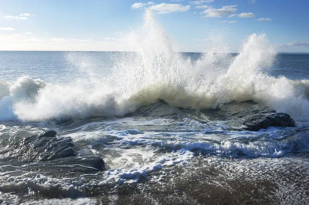 Gale Force Winds and torrential rain sweep through New Zealand
In the United States, many parts of the country received above-average snowfall this winter, and as spring-time warmth arrives, water levels in many rivers are rising to dangerous levels. Flooding has already been reported along stretches of the Mississippi river, particularly in Iowa, and concerns are increasing for parts of California. The region saw more than twice as much precipitation as expected over the winter due to a series of “atmospheric river” storms, which brought persistent, heavy rainfall and caused widespread flooding.

These storms also brought record amounts of snow to the Sierra Nevada mountains, with satellite measurements on April 1 showing the highest snowpack levels since records began in 2000. As temperatures have risen well above average across California during the past week, it has accelerated the snow melt, prompting the closure of parts of Yosemite National Park due to the flood risk. Cooler weather is expected to arrive in the coming week, which should at least temporarily slow the melting and reduce the flood risk.